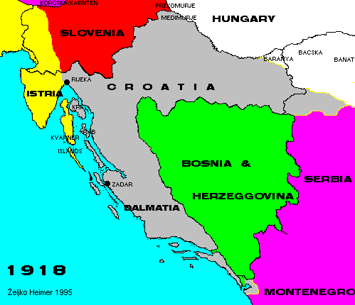

Toward the end of war countries in Austro-Hungaria declared independence. Souther Slavic states in Monarchy formed the State of Slovenes, Croats and Serbs including Slovenia, Croatia and Bosnia & Herzegovina.
Serbia and Montenegro united, and Serbian army marched into parts of the dying Empire. In many areas on the edges of Austria and Hungary proper plebiscites were held, and most of them were lately divided between newly formed Kingdom of SHS, and Austria and Hungary.
At the end of 1918 the Kingdom of SHS (now stands for Serbs, Croats and Slovenes) was formed out of united Montenegro and Serbia, and State of SHS.
Italian troops (D'Anunzio legionaries) occupied Istria and Slovene coast, and Dalmatia, and soon after Rijeka and islands. By the treaty of Rappalo 1924 the border between Kingdom of SHS and Italy was formed, with Rijeka, islands and Zadar remaining in Italy.
Back to Previous Map. Back to Chronology list. Proceed to Next Map.
This page is maintained by Zeljko Heimer.
If you have any comments or suggestions, don't hesitate, mail me to [email protected].
Last update 10 Aug 1997.
My counter log since 04-MAY-1996.