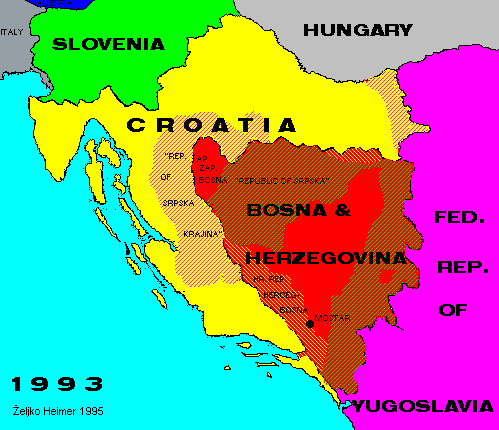
In year 1991 Croatia and Slovenia declared independence from Yugoslavia. Immediately Yugoslav army attacked Slovenia, but the war was shortly over. Because the pressure from Europe the independence was postponed for three months.
After that time Serbian aggression against Croatia started. Yugoslav army was banished from most of Croatia, but in central regions and in eastern Slavonia they couldn't be removed. There rebel Serbs from Croatia with help of Yugoslav army established "Republic of Srpska Krajina", unrecognized be anyone, and it existed until 1995 when western parts were reintegrated to Croatia. Eastern part, Eastern Slavonia and Baranja remained under Serbian occupation.
Soon after Slovenia and Croatia, Bosnia & Herzegovina also declared independence. Yugoslav army and Bosnian Serbs didn't recognized it, and began aggression instantly on Bosnian Muslims and Croats. As a way of organizing themselves against aggression where they were in majority, Bosnian Croats formed a Croatian Republic of Herceg-Bosna. Bosnian Croats and Muslims act cooperatively against aggression.
In western Bosnia in enclave of Bihac Muslim rebels against central government in Sarajevo declared Autonomous Region of Western Bosnia, which ceased to exist in 1995.
Both Croatia and Bosnia & Herzegovina is internationally recognized in borders as they were borders of federal republics in Yugoslavia, but as a result of aggression they don't act on hole of the territory now.
Back to Previous Map. Back to Chronology list. Back to Current Map.
This page is maintained by Zeljko Heimer.
If you have any comments or suggestions, don't hesitate, mail me to [email protected].
Last update 10 Aug 1997.
My counter log since 04-MAY-1996.